Walking Trails
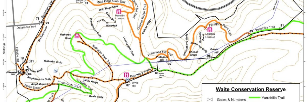
There are three marked trails through the Waite Reserve.
The 4 kilometres long Waite Loop starts at the bottom of Wild Dogs Glen and climbs to the Old Coach Road, before looping out to the western edge of the Adelaide Hills face. The trail returns to Gate 61 via the easement. This trail starts with a steep climb. Allow 2 -2.5 hours for the walk. Parking is available in the nearby University Carparks.
The 2.6 kilometre Sheoak Loop takes off from the Waite Loop near Gate 88 and initially follows the Yurrebilla Trail to Gate 89. At the gate, the 2 trails separate. From there it is mainly downhill to a large old quarry above the SE freeway. The return is a gentle one, as the trail uses the old horse trail from the quarry and the old Coach Road. Allow 40 - 60 minutes for the Sheoak Loop.
Part of the Yurrebilla Trail also traverses the Waite Conservation Reserve. This crosses our southern boundary from Carrick Hill and continues on a public walking track through Springwood Park to the old Mt Barker Road, below Eagle on the Hill. This trail is a narrow footpad, no steeper than 1:11 grade. Allow 45 minutes.
All walking tracks afford magnificent views over the Adelaide Plains to the sea.
For further details and information, please contact:
The Manager of the Waite Conservation Reserve Dr Kate Delaporte, phone 8313 7405.
Please note:
In summer, the average maximum day temperature is about 27°C, but there are often days of high 30s, so a hat and sunscreen are essential.
On Total Fire Ban days (for the Mount Lofty Ranges): The Arboretum, Gardens of Urrbrae House and Conservation Reserve are all closed to the public. Please check CFS website https://www.cfs.sa.gov.au/site/bans_and_ratings.jsp.
In winter, the ground can be very wet underfoot and boots or sturdy shoes are recommended.
NO DOGS are allowed in the Reserve except guide and assistance dogs.

