AuScope fund to unlock the secrets of Curnamona Province
Professor Graham Heinson, Director of the Mawson Geo Centre, and Deputy Director IMER, at the University of Adelaide, in collaboration with the Australian National University and the University of Melbourne, have recently been funded $1 Million by AuScope, the Earth Sciences NCRIS Capability to undertake a major new geophysics program across the Curnamona Province in South Australia and New South Wales. The project will also include the State Geological Surveys of South Australia and New South Wales, the federal agency Geoscience Australia, and industrial partners from the space technology and mineral exploration sectors.
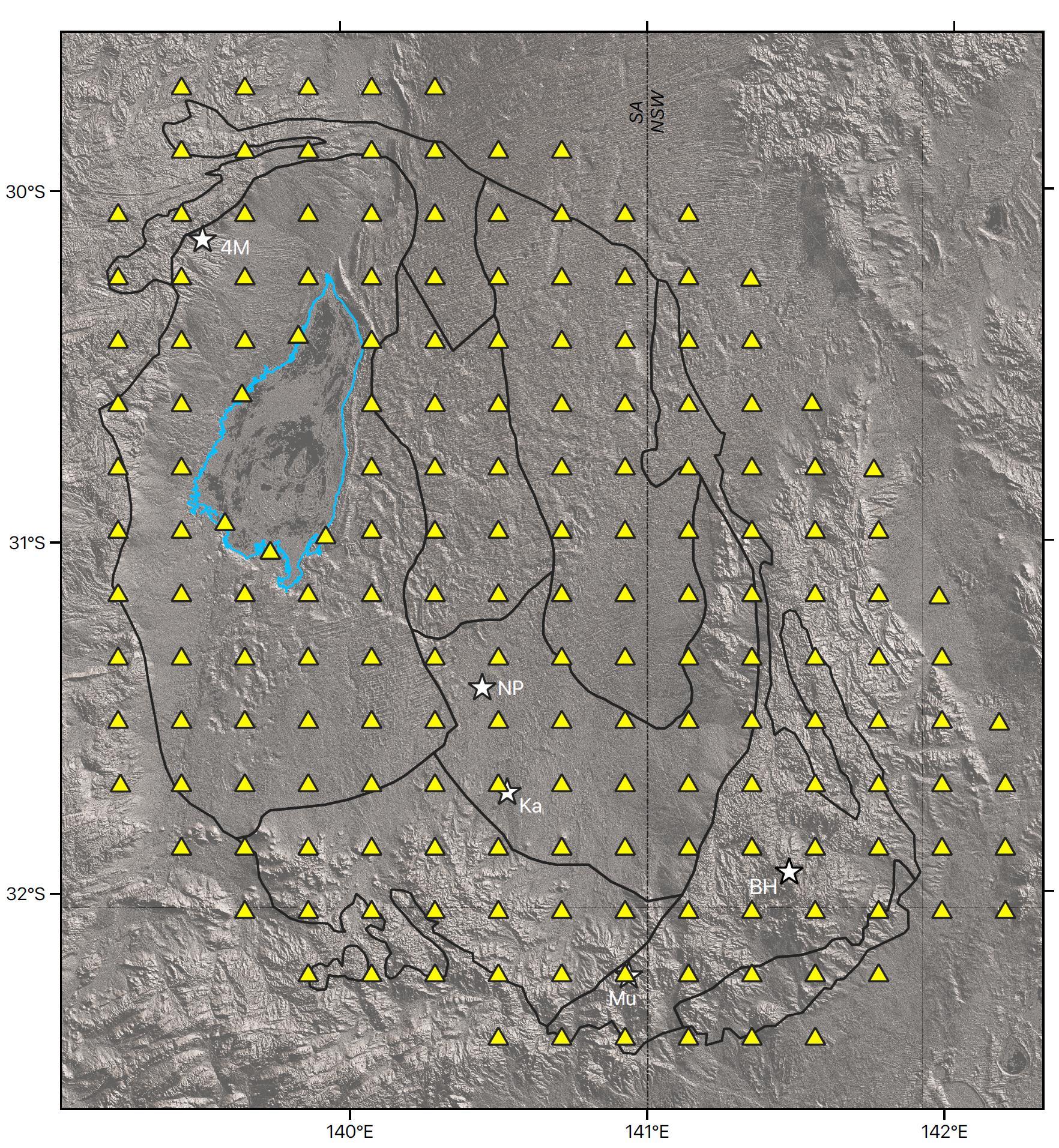
The Curnamona Province is a greenfields environment for mineral exploration due to extensive and deep sedimentary cover. As shown in the map below, the team will collect two world-class data sets for the research, government and industrial communities:
- Curnamona Cube. 200 MT and 200 seismic sites in a 20 km grid across the Curnamona Province over two years (yellow triangles). Survey dimensions 300 km by 300 km will generate data and models infrastructure from the surface to a depth of 300 km;
- Curnamona Telescope Super Site. As a pilot Super Site, we will establish a small grid of long-deployment MT, passive seismics and heat-flow needle probes close to the Kalkaroo deposit (Ka in figure).
The Curnamona is one of the great frontier opportunities for exploration undercover in Australia. Very little exploration has been undertaken relative to similar areas in the eastern Gawler Craton and the Mount Isa Province. Data and model outputs will be a globally unique resource: an entire Province defined geophysically, from the surface to the base of the Australian continental plate. The Curnamona Cube framework dataset and associated models for the entire Province will be of significant national benefit.

Figure: The extent of the Curnamona Province (and sub-Provinces, black lines). Yellow triangles show the MT and passive seismics sites proposed for the Curnamona Cube program. The blue outline is of Lake Frome, which is a dry salt lake. Mines and major deposits are shown as white stars (BH - Broken Hill; Ka – Kalkaroo, NP – North Portia, Mu – Mutooroo, 4M – Four Mile). The Curnamona Telescope Super Site potentially is located at Kalkaroo.
